
|
|
 |
|
|

|
This weather station's data (in addition to being displayed above) is uploaded real-time to Weather Underground. I also have a Tempest weather station that's uploaded here.
Other Hood River forecasts: NWS - (Forecast) (Weather Table) (Area Forecast Discussion) Windy.com multiple Wx Models Accuweather Wunderground TWC WeatherForYou MyForecast Forecast Advisor
NEW! Hood River's historic daily weather averages and records spreadsheet
Many thanks to Julia N. who several years ago converted the MCAREC database into spreadsheet form for me, which I have been updating ever since. Thanks also to Temira, who recently convinced me to share it online (and who also set it up in Google Docs).
Everybody Talks About the Weather...
So, here's yet another place to talk about it. Before posting, please read the more detailed chat room guidelines here. Please be polite, civil, and respectful of each other. Politics and anything else that turns into a heated argument or violates the chat room guidelines are not allowed, and comments that push that too far might be deleted (or you might be banned) at our discretion. You've been warned.
In the chat window below, the most recent comment is at the bottom; scroll up to see previous comments. To open a stand-alone chat window, click here. In fact, it would be a good idea to bookmark that just in case this weather site goes down, and you want to chat about what the heck is happening, and why, and how long.
Opinions expressed in the chat room are those of the people posting them, and not necessarily those of the management of this weather site, if it had any management.
This whole weather site auto-reloads every 15 minutes, wiping out whatever you are typing into chat room comments at that moment. So, to be on the safe side, reload the site before posting, by hitting "CTRL-R", or the F5 key, or however you prefer to reload web pages. Or, to avoid all that, just use the stand alone chat room.
|
|
|
|
|
|
|
|
|
|
|
|
|
|
|
|
Northwest radar loop. Current static image NWS NW radar UW radar

NE Pacific enhanced IR satellite loop below. Current static image is here. Current NW loop is here.

More Cams: HR Port Cams Skyline Hospital Cams IR HatchCam Sailworks: (Summer Winter) KOIN The Dalles Cam Oregon Coast All NW Cams Cascade Volcanoes
|
GorgeCurrent |
View South from Underwood |
Underwood Heights |
I-84 At Hood River |
|
HR Waterfront |
KOIN Mt Hood Meadows |
|
Rooster Rock |
|
Pacific City Ocean View |
US 35 At Parkdale |
US 26 at Government Camp |
KGW Portland Cams |
|
|
|
|
|
|
|
|
|
|


")

Previous 2 Weeks Wind Speed (Red) and Barometric Pressure (Blue)
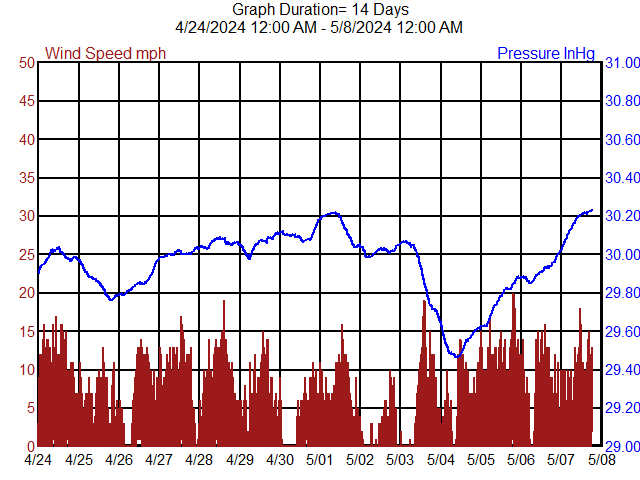
The wind speed at the weather station (1/2 mile south of Wal-Mart) is considerably lower than the wind speed on the Columbia River. When the west wind is blowing, add 10 to 20 mph for on-river conditions
Previous 2 Weeks Wind Direction (Red) and Barometric Pressure (Blue)
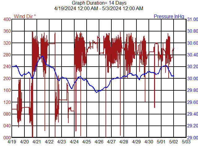
Wind direction is displayed in degrees (like a compass). Wind from due North is 0 (or 360) degrees, East is 90, South is 180, and a west wind is 270.
Current Month Temperatures (previous months here)
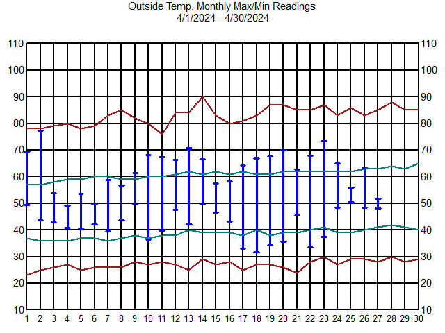
Daily Temperatures (Blue) Historical Averages (Green) Record Extremes (Red)
Current Month Precipitation (previous months here)
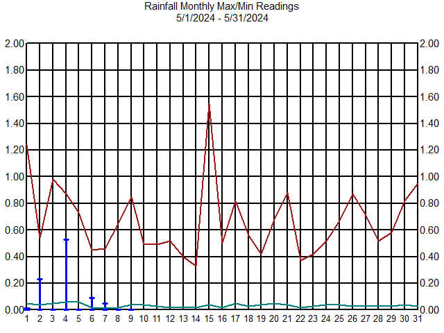
Daily Precipitation (Blue) Historical Averages (Green) Record Extremes (Red)
This site was designed (using the term loosely) and is maintained (barely) from 1998 to 2024 by me (hrw)